Youtube videók
Leírás és Paraméterek
|
|
|
|
|
|
|
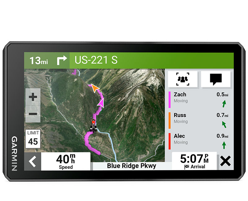
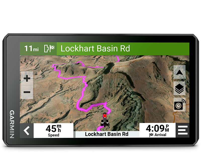
| The bright 6” display is easy to read, no matter the weather or light conditions. | Create custom routes with the visual route planner. | Find the twists and turns with the Garmin Adventurous Routing™ setting. | See popular moto paths to discover new places to ride. | Start a group ride to see positions of other riders on the zūmo XT2 display1. | Switch from North America street maps to topographic maps to satellite imagery with just a tap. |
Switch from North Americ
TOP FEATURES
|
|
|
ULTRABRIGHT DISPLAYThe 6” display is 15% larger than previous models and features an even brighter HD resolution in landscape or portrait mode. |
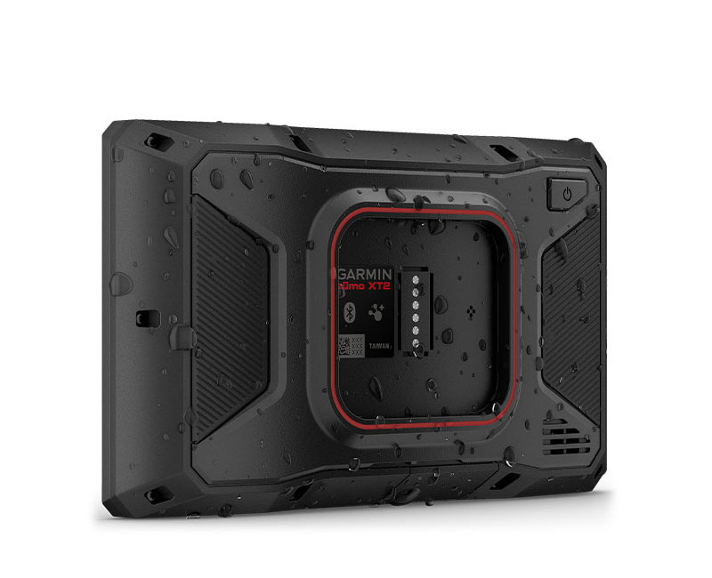
DESIGNED TO ENDURERain? Vibration? Dust? Doesn’t matter. This device is built to withstand all kinds of weather (IPX7) and rough terrain. |
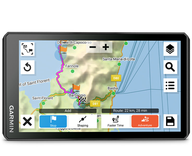
VISUAL ROUTE PLANNERPlan a custom route on the device, or use the Tread app with a compatible smartphone. |
|
|
|
SIMPLE MAP SWITCHINGQuickly toggle between on-road maps, topographic maps and satellite imagery, so you can always have the perfect map for your ride |
GROUP TRACKINGUse the Tread app on your smartphone and/or zūmo XT2 device to track friends with the Group Ride Mobile feature1. Or, use the Group Ride Radio accessory2 (sold separately) for tracking other zūmo XT2-equipped riders with no cellular coverage needed. |
SATELLITE IMAGERYUse satellite imagery from around the world to help you navigate. Download the maps directly to your device via Wi-Fi® technology3. No annual subscription required. |
DESIGNED FOR RIDERS. ENGINEERED FOR MOTORCYCLES.
NAVIGATION
|
|
|
|
|
|
POPULAR PATHSSee popular moto paths ridden by other riders to find new and exciting routes to explore. |
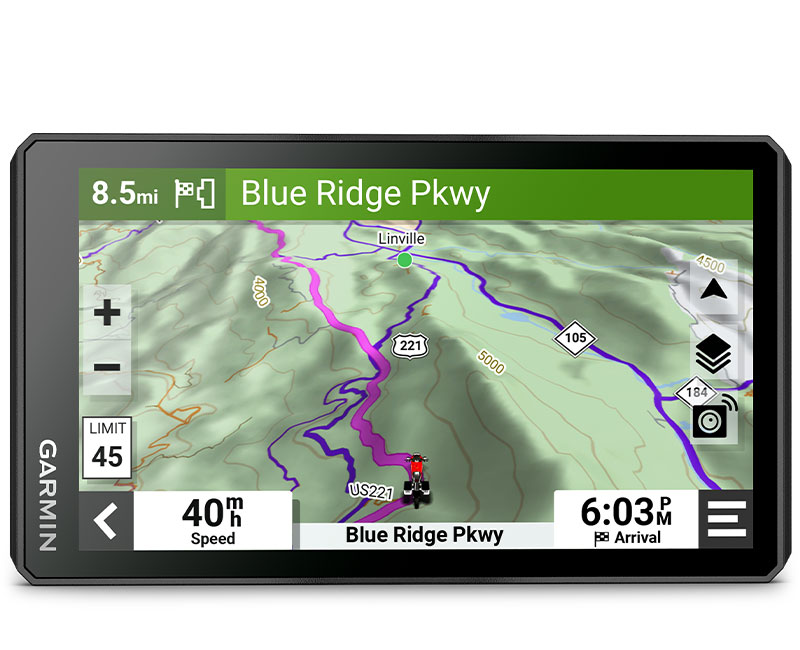
GARMIN ADVENTUROUS ROUTINGStraight roads are boring. Find the most thrilling routes with hills, curves and sights, and choose from 4 levels of difficulty. |
RIDE SUMMARIESUse the Tread app to review your ride details, including speed, acceleration, decelerations, elevation and more. |
TRACK RECORDERRecord your ride data such speed, distance, acceleration and more and share the details with friends on Tread app. |
SHARE YOUR FAVORITE ROUTESEasily send GPX files from your phone or third-party sources to your zūmo XT2 navigator. Share GPX files with fellow riders by using the Tread app. |
TRAVEL FEATURES
|
|
|
|
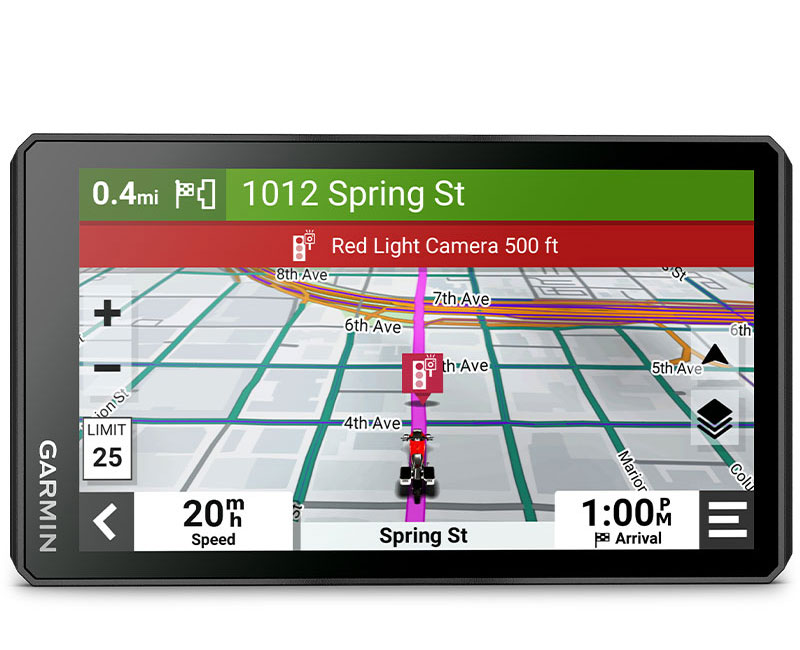
RIDER ALERTSGet alerts for hazards along your route, such as upcoming sharp curves, speed changes and more. You’ll also be notified about state helmet laws and red light#slspeed cameras4. |
MANAGE YOUR DATAEasily manage5 tracks and routes across your navigator and compatible smartphone by using the Tread app. |
MUSICStream music from your smartphone through the zūmo XT2 navigator, or play MP3 files stored on the navigator — all to your connected helmet or headset. |
CONNECTED FEATURES
|
|
|
|
|
|
|
WIRELESS UPDATESBuilt-in Wi-Fi connectivity3 makes it easy to keep your maps and software up to date without using a computer. On-screen cues show when new updates are available. |
LIVE TRAFFIC AND WEATHERAccess real-time traffic and weather, share routes with other riders, and get phone notifications via the Tread app5. |
INREACH® COMPATIBILITYPair zūmo XT2 with a compatible inReach satellite communicator6 for two-way messaging, location sharing and, in case of emergencies, SOS capabilities. |
BLUETOOTH® CONNECTIVITYHear turn-by-turn directions or stream music from your compatible smartphone through a connected helmet or headset. |
INCIDENT NOTIFICATIONSIf an incident occurs, a text message with location information is automatically sent to your predetermined contact5. |
CONTROL YOUR ACCESSORIESPair the zūmo XT2 motorcycle navigator with the compatible Garmin PowerSwitch™ digital switch box (sold separately) to enable on-screen control of your motorcycle’s 12-volt electronics. |

| Dimension | 6.15"W x 3.5"H x 1"D (15.6 x 8.9 x 2.5 cm) |
| Display Size | 5.3"W x 3.0" H (13.3 x 7.5 cm); 6" diag (15.3cm) |
| Display resolution | 1280 x 720 pixels |
| Display Type | multi-touch, glass, high brightness HD color TFT with white backlight |
| Dual-orientation display | |
| Weight | 12 ounces (340 g) |
| Waterproof | IPX7 |
| Battery type | rechargeable lithium-ion |
| Battery life | up to 6 hours (up to 3.5 hours at 100% backlight) |
| Drop rating | MIL-STD-810 |
| Handlebar mount | (up to 1") |
| Maps & Memory | |
| Preloaded street maps | |
| Data cards | microSD™ card (not included) |
| 3D Terrain | |
| Internal storage | 32 GB |
| Ability to add maps | |
| External memory storage | yes (256 GB max microSD™ card) |
| Includes map updates | |
| Downloadable Satellite Imagery | yes (BirdsEye) |
| BirdsEye Direct Satellite Imagery | |
| Sensors | |
| GPS | |
| Galileo | |
| 10 Hz multi-GNSS positioning | |
| Outdoor Recreation | |
| Point-to-point navigation | |
| Preloaded topographical maps | |
| Navigate-a-track navigation | |
| Navigation Features | |
| Visual route planner | |
| Garmin Real Directions™ landmark guidance | |
| TripAdvisor® Traveler Ratings | |
| Route shaping through preferred cities#slstreets | |
| Includes traffic | yes (with Garmin Tread app) |
| Lane assist with junction view (displays junction signs) | |
| BLUETOOTH® pairing | yes (works with BLUETOOTH-compatible helmet, headset or smartphone. BLE capable.) |
| Speed limit indicator (displays speed limit for most major roads in the U.S. and Europe) | |
| Driver alerts for sharp curves, school zones, red light and speed camera warnings and more | |
| Advanced Features | |
| Smart notifications via app | |
| Wi-Fi® map and software updates | |
| Access to live services via app (traffic, weather, etc.) | |
| Motorcycle Features | |
| Control music and media from smartphone or MP3 player | |
| Sunlight readable and weather resistant | |
| Garmin Adventurous Routing™ | |
| Rider alert warnings for sharp curves, state helmet laws, speed cameras and more | |
| Planned & dynamic fuel stops | |
| Motorcycle or powersports specific points of interest for cycle repair services, dealers and more | |
| Helmet law notifications | |
| Popular paths (Moto) | |
| Elevation profile | |
| Round trip routing | |
| Service History Log | |
| Track support | |
| Custom map support | |
| TOPO map support | |
| Wireless ANT+® technology | |
| Adventure Features | |
| Pair with compatible inReach® devices | |
| Pair with Garmin PowerSwitch™ digital switch box | |
| Compatible with Group Ride Radio | yes (6", 8" and 10") |
| Group Ride Mobile | |
| Track recorder (breadcrumbs) | |
| Compatible with the Garmin Tread app for route planning and data management (waypoints, tracks, and routes) | |
| iOverlander™ points of interest | |
| Ultimate Public Campgrounds | |
| Glove-friendly touchscreen | |
| Group Ride Radio | |
| Radio Frequency Band | compatible with Group Ride Radio |
| Group Ride tracking | compatible with Group Ride Radio |
| Group Ride voice communications | compatible with Group Ride Radio |
| Radio transmitted canned messages | compatible with Group Ride Radio |
Kapcsolódó termékek


Vélemények
Erről a termékről még nem érkezett vélemény.